Skip to content
The Serengeti National Park Map and Planning Guide
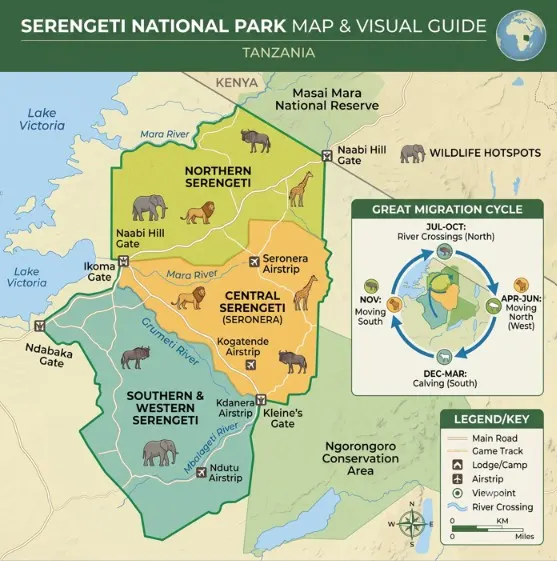
Summary: The Serengeti covers 14,763 square kilometres, roughly the size of Northern Ireland, so “where in the park” matters as much as “which park.” It splits into five regions (Central, North, West, South, East), reached through a handful of gates or a dozen small airstrips. This guide walks the map region by region, lists the gates and airstrips with real drive times, and shows where the wildebeest migration sits through the year, which is the single thing that should shape your route.
Jump to Section
Most people picture the Serengeti as one place. On the map it is really five, each with its own character and wildlife and its own best season, and the difference between a good trip and a frustrating one is usually just picking the right region for your dates. A lodge in the north in February puts you 300 kilometres from the calving herds in the south. This guide is the map read out in plain language, so you know where things are before you commit to a route.
If you would rather we simply build the route for you, send your dates on the quote page and we will map it around the wildlife.
How Big the Park Is
Metric / Route | Value / Time | Key Context |
Total Park Size | 14,763 km² | Size of Northern Ireland |
Arusha to Naabi Gate | 325 km (4-5 hrs) | Full-day overland road drive |
Naabi Gate to Seronera | 45 km (1-1.5 hrs) | Central hub transit corridor |
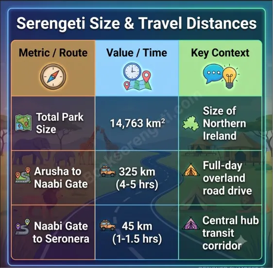
The Serengeti National Park is 14,763 square kilometres (5,700 square miles). That is large enough that crossing it by road is a full day, and it sits inside an even bigger ecosystem that includes the Ngorongoro Conservation Area to the southeast and the Mara River system feeding Kenya’s Masai Mara to the north.
Two numbers help as you read the map. Seronera, the central hub, sits roughly in the middle and is about 45 kilometres from the main Naabi Hill Gate. And a straight drive from Arusha to the park is 325 kilometres and takes most of a day, which is why most people break the journey or fly.
The Five Regions
The park divides into five sectors. Knowing which is which is most of what reading this map comes down to.
Central (Seronera). The heart of the park and the busiest sector. Seronera has the highest year-round density of resident wildlife, especially lions and leopards along the river valley, plus the main airstrip, fuel, and the visitor centre. It is the best base for wildlife year-round. If you only see one region, it is this one.
North (Kogatende and Lamai). The far north, up against the Kenyan border. This is Mara River crossing country, the July-to-October headline act, and it stays quieter and greener than the centre. A long way by road, so most people fly in.
West (the Western Corridor / Grumeti). A tongue of land reaching toward Lake Victoria, following the Grumeti River. Its moment is roughly June, when the herds pass through and the Grumeti crossings happen. Tsetse flies are thicker in the western woodlands.
South (the short-grass plains / Ndutu). Open, treeless plains that flow into the Ngorongoro Conservation Area. This is where the migration calves from December to March, and because it is technically in the Conservation Area, off-road driving is allowed there, which the main park does not permit.
East (Namiri and the eastern plains). The remote, little-visited side. Namiri Plains is the old cheetah country here, reopened to only a couple of camps, and it is the sector for people who want space and predators without crowds.
Gates and How to Reach Them
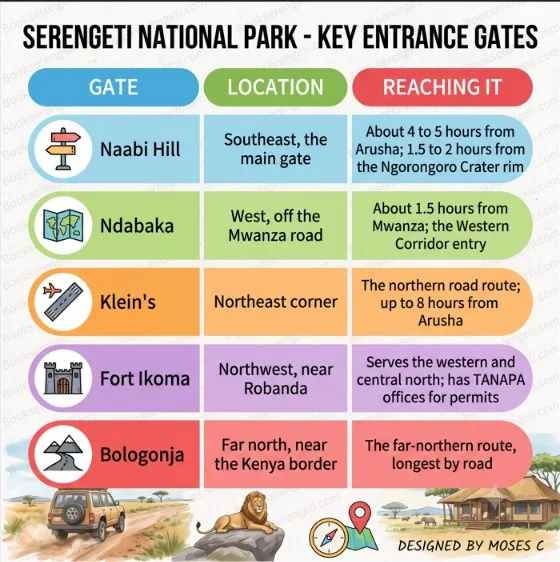
You enter through one of several gates depending on which direction you come from. Gates open 06:00 to 18:00, with last entry usually 16:00.
Gate | Location | Reaching It |
Naabi Hill | Southeast, the main gate | About 4 to 5 hours from Arusha; 1.5 to 2 hours from the Ngorongoro Crater rim |
Ndabaka | West, off the Mwanza road | About 1.5 hours from Mwanza; the Western Corridor entry |
Klein’s | Northeast corner | The northern road route; up to 8 hours from Arusha |
Fort Ikoma | Northwest, near Robanda | Serves the western and central north; has TANAPA offices for permits |
Bologonja | Far north, near the Kenya border | The far-northern route, longest by road |
Naabi Hill is the one most road trips use. It sits between the southern plains and the central Seronera area, so it works as the gateway from the Ngorongoro side, and your guide clears permits and park fees there before you drive on.
Airstrips and Fly-In Points
The park has close to a dozen airstrips, which is how most people skip the long drives. The key thing is to fly to the strip nearest your camp, because a wrong choice means a long, expensive transfer once you land.
- Seronera (SEU): the central, primary airstrip, with fuel, a small terminal, and the shortest transfers to central lodges. About 1 to 2 hours’ drive from Naabi Hill.
- Kogatende: the northern strip for the Mara crossing camps, July to October.
- Ndutu and Kusini: the southern strips, for calving-season camps December to March.
- Grumeti and Sasakwa (Kirawira): the Western Corridor strips.
- Lobo: the northeastern strip, for the Lobo valley and Klein’s area.
Light aircraft here are Cessna Caravans and similar, with a strict 15 kg (33 lb) soft-bag luggage limit, so the map point you fly to determines your whole packing plan. See our airstrips guide for the full breakdown.
Where the Migration Is, by Month
The migration is what should move your pins around the map. It runs a continuous loop, shifting a couple of weeks each year with the rain.
Months | Region on the Map | What’s There |
Dec to Mar | South (Ndutu) | Calving, up to 8,000 calves a day at the February peak |
Apr to May | Central, moving | Herds funnelling north through the green season |
Jun | West (Grumeti) | The quieter Grumeti River crossings |
Jul to Oct | North (Kogatende) | The Mara River crossings, the peak spectacle |
Nov | East, returning south | Short rains, herds streaming back toward the plains |
Match your month to this table, then pick the region, then the camp. Get that sequence wrong and you can end up based a full day’s drive from the herds. Our migration guide goes deeper on the timing.
Driving vs Flying the Map
Mode | Travel Time | Best For |
Drive Safari | Full day (325 km) | Scenic view & lower budget |
Fly-In Safari | 1 – 2 hours | Far regions & short stays |
Hybrid Route | Half day + flight | Drive in via Ngorongoro, fly back |
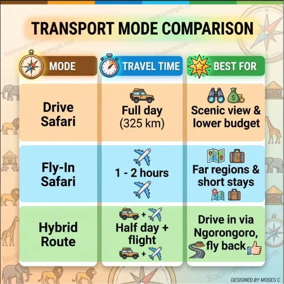
Two ways to cover this map, and most good trips use both.
Driving in lets you see the country change, from the Ngorongoro highlands down onto the plains, and it is cheaper. The cost is time: Arusha to Seronera is most of a day, and Seronera to the northern crossings is another 5 to 6 hours on rough road. A 4×4 is essential; ordinary cars cannot manage the tracks, especially in the wet.
Flying saves those long transfers and is the sensible way to reach the far north or the remote south for a short trip. The usual pattern is to drive in through the Ngorongoro side, which is scenic and breaks the journey, then fly back from Seronera on the last morning rather than repeat the long drive.
Map FAQs
How big is the Serengeti National Park?
14,763 square kilometres (5,700 square miles), about the size of Northern Ireland or the US state of Connecticut. It sits within a still-larger ecosystem that includes the Ngorongoro Conservation Area and Kenya’s Masai Mara.
How long is the drive from Arusha to Naabi Hill Gate?
Roughly 4 to 5 hours to the gate, though the full drive on to central Seronera is closer to a full day at 325 kilometres. From the Ngorongoro Crater rim, Naabi Hill is about 1.5 to 2 hours.
What are the main airstrips inside the Serengeti?
The most-used are Seronera (central), Kogatende (north), Ndutu and Kusini (south), and Grumeti and Sasakwa (west), plus Lobo in the northeast. You fly to whichever is closest to your camp.
Can you drive yourself around the Serengeti with a map?
Yes, self-drive is allowed in a 4×4, but it is not recommended for first-timers. Cell coverage is patchy, signage is thin, the tracks are confusing, and there is no quick help if you get stuck. Most people who self-drive carry offline GPS (Maps.me or a similar app) and still find a guide’s knowledge of where the animals are worth far more than the map alone.
Which gate is closest to Ngorongoro?
Naabi Hill Gate, about 1.5 to 2 hours from the crater rim, is the standard route between the Ngorongoro Conservation Area and the Serengeti.
Plan Your Serengeti Route
The order that works: pick your month, use the migration table to find the right region, then then a gate or airstrip, then a camp in that sector. Get the region right and the rest of the trip gets a lot easier to plan.
If you would like the routing done for you, with the gate, airstrip, and camps matched to where the wildlife will actually be, tell us your dates on the quote page. Karibu.
About the Author I’m Moses C.. I’ve spent fifteen years driving every corner of this map and running the field logistics behind the scenes at BookSerengeti.com. Tell me your month and I can point to the exact stretch of the park where you should be standing.
Welcome to bookserengeti.com
Thank you for visiting us! We're excited to help you plan an unforgettable safari adventure across Kenya.
Latest Safari Posts
Serengeti Migration Safari Packages: 2026/2027 Cost & Itinerary Guide
Serengeti Wildlife Safari Packages: 2026/2027 Price, Big Five & Routes
Serengeti Group Joining Safari Package: 2026/2027 Price & Route Guide